
Managing boat activity: A novel River Murray drone study with broad implications
World first study using drones to assess bank erosion from sub-daily movements of boats and river operations. The approach signals a new phase of monitoring using drones to build knowledge and improve management of river operations and recreation, preserving ecological, community and cultural values.
Boat wake test in progress on the River Murray
Recreational boating is popular and widespread on inland waterways across Australia. The impacts, however, for active bank erosion are well-documented, with multiple knock-on effects for river operations, particularly in locations such as the lower River Murray.
Previous monitoring under the River Works Monitoring Program was undertaken by the NSW Soil Conservation Service (SCS) on behalf of the Department of Planning and Environment (DPE) with funding from MDBA. Early work could only suggest impacts from boat wakes and combined river flows, and there were challenges untangling the relationship between different drivers of erosion, namely river flow (and water level), the type of boat, and the way it is operated. Our knowledge of the relationship between erosion severity, vessel wake and river flow has been lacking.

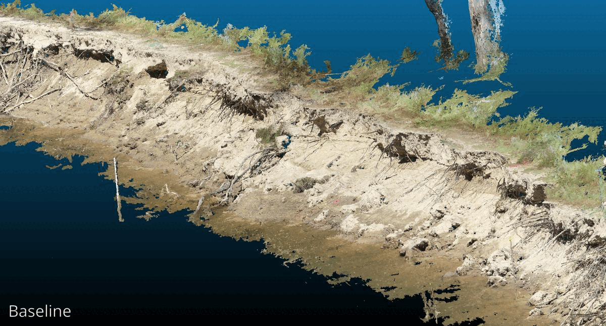
Study site on the River Murray
Streamology has been leading the development of the use of drones in waterway physical form monitoring and this project was a significant extension to what was previously possible. In a joint field experiment using drones (designed collaboratively by SCS, MDBA and Streamology) we quantified bank erosion in response to boat and river operations scenarios. Erosion was measured across a section of riverbank using very high-resolution, close-range drone photogrammetry in response to multiple vessel types and operating modes (each 50 passes), and different river flows. Drone 3D models were captured before and after each scenario.
Bank erosion animation using 3D drone models
The results were of sufficient resolution to differentiate impacts from different vessel types, operating modes, and flows — something not previously possible. The results were conclusive that boat wake generates more erosion than flows alone, and the operating mode and river level were found to be crucial factors. This knowledge now provides demonstrable evidence to inform effective and equitable controls to protect riverbanks. In particular, basing restrictions on the operating mode rather than specific activities (e.g. ‘no slow towing’ rather than ‘no wakeboarding’) focusses on the key factor rather than targeting specific user groups. The knowledge also informs river operations to minimise riverbank impacts such as through lower water levels for popular boating periods (summer weekends and public holidays). The findings will assist water and waterway managers in designing flows and regulations that balance the needs of the community and environment on the River Murray, and inland waterways throughout Australia.
The project demonstrates the value of high-resolution drone data and provides crucial insights about form, processes and drivers of change, to quantify links to water and waterway management.